

I did the West Highland Way in June 2018 with a group of friends who are experienced, but not necessarily light or adventurous backpackers. While the West Highland Way is a beautiful and worthwhile experience, by the final day of the trip I wanted to pick up the pace and make my own way further into the backcountry before reaching the WHW’s terminus in Fort William. I devised a path that went over some of the area’s great ridgelines along the way to the summit of Ben Nevis. While this is a long and arduous day compared to the WHW’s established shorter day, the rewards are many and worth it.
Basic Route: Kinlochleven to Fort William
Stats (I recorded a track)
19 miles (17.3 on trail)
7,750 vertical gain
4,413 feet highest point (Summit of Ben Nevis)
Date: June 10, 2018
Logistics:
It’s worth considering whether you are up for 17 plus miles with 7000 plus vertical gain in a single day that is mostly unmaintained trail or use path. I’d suggest having preparation for a night in the backcountry due to weather or exhaustion even though the major town of Fort William lies at the end of the day. Opportunities for unexposed wild camping exist near Steall Falls and continue on until the ascent of Carn Mor Dearg if you were to split this into two days. There is beer and haggis to be had at the end of the day if you do it in one!
Difficulty:
Trails and use paths in this area are not maintained and in some places not obvious except for the summit of Ben Nevis down to Achintee. There are class two scrambles, exposed ridgelines, boggy ground, and a lot of elevation gain for a single day’s hiking. This route should not be attempted in bad weather or by a hiker unused to navigating without the aid of GPS or with limited sight lines, as visibility can be quite poor even on good weather days.
Description:
Leaving Kinlochleven you’ll follow the signs towards the Grey Mares waterfall, but instead of going to the falls settle on a path that follows the Allt Coire Na Ba river north. This trail stays just a little east of the watershed through some range land and a wide open canyon, gaining spectacular views of Kinlochleven below as you gain elevation.


You’ll continue your climb curling north east around an imposing head wall until you gain a ridgeline, and then follow the ridgeline west to the summit of Stob Coire a Chairn.

From the summit of Stob Coire a Chain you’ll head north, dropping down into a little saddle before climbing up to a prominince that obscures your view of the summit of An Gearanach. From the summit of Stob Coire a Chairn this does not look like a possible or wise route, but it actually just leads to a little light exposed scrambling to attain the next ridgeline and make your way towards An Gearanach. The views here are outstanding, with wide open valley floors both to the east and west, 2000 feet or more below on both sides.
Here my finger is pointed directly at the climb I’ll be doing from one summit to the next:

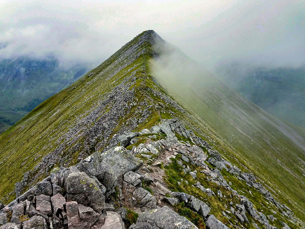
Once you’ve gained the next ridgeline you have smooth but narrow sailing:
And a look back at the traverse:

From here there is a straightforward, on trail,, though steep, northbound descent into the river valley below:


Waiting for you at the bottom are the ‘Waters of Nevis’. Cross the river and follow a trail westbound until you reach the Allt Coire Guubaschen, a creek you’ll follow northbound, climbing past a waterfall up to a wide open floodplain. At the end of the floodplain you’ll find a headwall leading to a pass below the climb to Carn Mor Dearg. The path for most of this segment is both indistinct and unnecessary, though the floodplain is marshy and could be quite treacherous earlier in the season or after a heavy rain. Though the climbing is steady, the views both of where you have been and are going are wonderful, and reminiscent of formations at much higher altitudes. Once you’ve completed the climb out of the floodplain you’ll have to pick an eastbound line to the ridgeline of Carn Mor Dearg, if there was a use trail or obvious path I missed it, but not for lack of looking. Regardless, a little common sense of avoiding some of the looser smaller rock on the ascent and the climb is within the abilities of anyone physically able.
A look across the flood plain to the pass:

And a look back from the pass south towards An Gearanach:

Climbing from the saddle to the Carn Mor Dearg summit I became socked in by fog for almost the remainder of the trip, which dimished views but still made for fun hiking. At the summit of Carn Mor Dearg you follow the arete south and west to a rock hopping approach to the Nevis summit, and it’s all down hill from there, literally.
Taking a break on the arete:

Obscured cloudy views:

Nevis Summit monument:

Leaving the Nevis Summit you can take the ‘tourist path’ down to Fort William. At the bottom of Nevis there is a camping ground with a good restaurant, or plenty of places in Fort William to celebrate the proper end of the West Highland way, including the statue of the ‘Walker’ rubbing his sore feet:
Since the last day of the West Highland Way doesn’t have any must see towns along the way, and according to some is subpar scenery and road walking compared to much of the route, this is a handy way to turn your West Highland Way finale into some type 2 fun.
Comments